Tocht Andere activiteiten Le Ménil - Randonnée des Chapelles - Photo

Randonnée des Chapelles

 jeanclaude12
jeanclaude12

Gebruiker

© OpenStreetMap contributors
Lengte
Lengte
21 km
Max. hoogte
Max. hoogte
1058 m
Positief hoogteverschil
687 m
Km-Effort
Km-Effort  
30 km
Min. hoogte
Min. hoogte
524 m
Negatief hoogteverschil
687 m
Boucle
Boucle
Ja
Datum van aanmaak :
2014-12-10 00:00:00.0
Laatste wijziging :
2014-12-10 00:00:00.0

(0 Bericht)

Andere activiteiten
Andere activiteiten
5h48
Moeilijkheid : Onbekend

Scan deze QR-code om de tocht te openen in de SityTrail-applicatie

Gratisgps-wandelapplicatie

Logo SityTrail SityTrail

IGN / Geografische instituten

SityTrail uit de App Store downloaden SityTrail uit Google Play downloaden

Logo SityTrail SityTrail World

De wereld gaat voor u open

SityTrail uit de App Store downloaden SityTrail uit Google Play downloaden SityTrail op Huawei AppGallery downloaden

Over ons

Tocht Andere activiteiten van 21 km beschikbaar op Grand Est, Vogezen, Le Ménil. Deze tocht wordt voorgesteld door jeanclaude12.

Hoogteprofiel

Foto's

POI's

POI Le Thillot - Chapelle des Vés - Photo
jeanclaude12
LE THILLOT 
POI Fresse-sur-Moselle - Camp du Maquis du Peut-Haut - Photo
jeanclaude12
FRESSE-SUR-MOSELLE 
POI Le Ménil - Chapelle de la Pitié - Photo
jeanclaude12

Plaatsbepaling

Land:
France
Regio :
Grand Est
Departement/Provincie :
Vogezen
Gemeente :
Le Ménil
Locatie:
Unknown
Vertrek:(Dec)
Vertrek:(UTM)
334733 ; 5308723 (32T) N.

Wandeltochten in de omgeving

Tocht Stappen Le Ménil - Boucle au départ des chalets de la
Stappen
dboon

Stappen

Gemakkelijk
(3)
Le Ménil, Grand Est, Vogezen, France
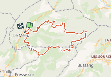
10 km | 14,1 km-effort
3h 0min
Ja
Tocht Stappen Ventron - 2022-02-19 Marche Ventron Tête des Champs - Photo
Stappen
GUIDE
holtzv

Stappen

Zeer moeilijk
Ventron, Grand Est, Vogezen, France
22 km | 34 km-effort
5h 52min
Ja
Tocht Te voet Fresse-sur-Moselle - Les ballons à l’horizon - Photo
Te voet
PRO

Te voet

Gemakkelijk
Fresse-sur-Moselle, Grand Est, Vogezen, France
7,7 km | 12,6 km-effort
2h 51min
Ja
Tocht Stappen Saulxures-sur-Moselotte -  Vosges saulxure sur Moselotte Etang des fées  coteau du bambois 3,6km 22072019 - Photo
Stappen
alain.guillaume

Stappen

Gemakkelijk
(2)
Saulxures-sur-Moselotte, Grand Est, Vogezen, France
3,6 km | 4,7 km-effort
1h 22min
Ja
Tocht Mountainbike Bussang - Vtt de Bussang 2 - Photo
Mountainbike
GUIDE
pascalou73

Mountainbike

Gemakkelijk
Bussang, Grand Est, Vogezen, France
9,6 km | 12,3 km-effort
49min
Ja
Tocht Stappen Bussang - Trek alsacien (boucle rochelotte) - Photo
Stappen
Godasses et Grosses Pattes

Stappen

Gemakkelijk
Bussang, Grand Est, Vogezen, France
8,1 km | 11,7 km-effort
2h 39min
Ja
Tocht Te voet Saulxures-sur-Moselotte - Col du rhamné depuis cirque de grettery - Photo
Te voet
Emmanuel Remy

Te voet

Gemakkelijk
(1)
Saulxures-sur-Moselotte, Grand Est, Vogezen, France
5,4 km | 9 km-effort
2h 2min
Ja
Tocht Stappen Fresse-sur-Moselle - Croix de Fresse - Vosges - France - Photo
Stappen
boulou300

Stappen

Medium
(1)
Fresse-sur-Moselle, Grand Est, Vogezen, France
13,4 km | 19,6 km-effort
3h 10min
Ja
Tocht Stappen Le Ménil - Grande boucle au départ des chalets de la Feigne sur de l'Eau - Photo
Stappen
dboon

Stappen

Moeilijk
Le Ménil, Grand Est, Vogezen, France
21 km | 31 km-effort
5h 31min
Ja


Sluiten
Mijn abonnementen